|
Some
who ride often in the Sierra Nevada Mountains say, “The Loney Meadow area is the
most picturesque of them all.” There are over 14 lakes visible on one 12 mile
loop and 12 other lakes nearby. The views are incredible.
There are numerous trails with some trails linked by dirt roads. The trails are
often rocky and range from 6000’ to 7200’. Horses should be shod and relatively
fit. There is plenty of water on the trail for the horses. Many of the trails
are marked but it is recommended that you get a forestry topographical map with
the trails and lakes on it.
There are occasional bikes and backpackers, but no motorized vehicles on the
trails. There can also be snow patches on the trail as late as July 4. The
campsite is very primitive. It has a stream for horse water but no people water
or bathrooms. There is room for at least 15 rigs and plenty of trees to tie to.
There are no fees or reservations. The area is closed during the snow season.
|
Loney Meadow is about 1/2 mile from the campsite. It is a large meadow with an
interpretive marked trail around it. This was the site of a historic dairy in
the late 1800’s to early 1900’s. They took milk in wagons over 40 miles down a
dirt road (now Hwy 20), to Nevada City. One rider speculates, “We would think
they would have butter, not milk, by the time they got there.” In the fall they
had to herd the dairy cows back to Nevada City for the winter. At the northwest
end of the meadow you can find what is left of the old homestead. At the
northeast end of the meadow there is a large grove of huge, old, quaking aspen
trees. |

Walt Reno guides happy LBHA members to
lakes near Grouse Ridge |
|
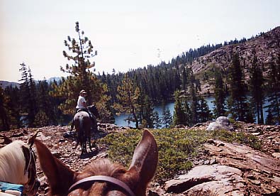
Lake View near Grouse Ridge |
Once on horseback, there are several directions you can ride.
1) Ride north along the dirt road about 1/2 mile to the Loney meadow trailhead.
Once in the Meadow, you can 1a)continue North and explore the country past the
old homestead. There is an older trail from Upper Rock Lake to the homestead but
it is hard to find from this end. Or,
1b) you can go around the meadow and head east
toward Lower and Upper Rock Lakes and
Culbertson Lake.
|
From Upper Rock Lake, you can ride
2a) circle back north and east on a trail that
overlooks Bowman Lake and return back to Loney Meadow;
2b) you can ride up to Penner Lake at the top
of the mountain and overlook the whole dang country;
|
2c) you can ride further east and hook up with
the trail between Sawmill Lake and Grouse Ridge Lookout. Once on the Grouse
Ridge Trail, it is possible to create a 12 mile loop by heading south and toward
the lookout and turning west on the trail to Island Lake, Carr Lake, and camp.
Another option from camp is to go 3) east up another dirt road to Lower, Middle,
and Upper Lindsey Lakes. From there it is easy to connect to the trail past
Culbertson Lake and back to Loney Meadow and camp.
4) A final option from camp is to head South
and cross the stream in camp. About 100 yards south of the crossing turn left
onto a trail and head east. It will climb up to another dirt road and from there
you can ride to either the Carr Lake trailhead or Lower Lindsey Lake trailhead.
4a) If you want a 16-mile up-and-back ride with
gorgeous views, you ride to the Carr Lake trailhead and continue east past
Island Lake, Milk Lake, and along the lower Sand Ridge Trail to Glacier Lake.
This ride is a favorite.
|
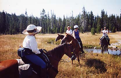
Crossing Loney Meadow |
DIRECTIONS: Take Interstate 80
eastbound. Forty miles past the Foresthill exit (in Auburn), exit onto Hwy 20.
The exit circles under the freeway and goes downhill. About 4 miles after
leaving Interstate 80, turn right onto the road to Bowman Lake. Continue toward
Bowman Lake for 10 miles until the pavement ends. (The pavement ends before you
get to Bowman Lake.) Do not take the road to Lindsey Lakes and Carr Lake at the
8.2 mile post. About 100 yards after the pavement ends, take the dirt road on
the right. As you leave the Bowman Lake road, the dirt road you are on splits
into two roads, a very steep road on the right and a steep-but-manageable road
on the left. Take the left road. (If you have 4-wheel drive, switch it on.)
After 200 yards you will come to a logging deck and a clear c ut. At that point,
swing to the right to return to the dirt road at the top of the steeper grade.
Drive up the dirt road about a quarter mile. As you enter the trees, the larger
camping area is on the left and smaller camping areas and the stream are on the
right. Park somewhere, saddle up, and have fun.
|