Location:
North of Hwy 65, near Sheridan and Camp Far West, adjoining Beale
AFB
Reviewed: August 2002
|


   |
Spenceville Wildlife Area is more
than 11,000 acres to explore on horseback. Trails go through streams, over
wide fields of oak woodlands, past historical remnants of Army practice
maneuvers during World War II, through fields of wildflowers in Spring, past
Nisenan and Maidu grinding rocks, and even to Fairy Falls, a beautiful
45-foot waterfall. From some high ridges, on a clear day you can see the
Sutter Buttes. Spenceville is also a birdwatcher’s destination, with 175
species observed within its borders.
|
The State Department of Fish and Game manages the area, and allows hunting
from Sept. 1 to Jan. 31. Turkey hunting is allowed from March 27 to May 2.
Riders should know there is a shooting range nearby that occasionally sounds
too close for comfort (but it’s not!) During summer 2002, riders noted that
although there are maps of Spenceville, and good ones at that, Fish and Game
does occasionally re-fence sensitive areas, thereby requiring riders to do a
little creative trail making. For many years, not too long ago, fox hunters
cantered cross-country here, with no footing worries, so the footing is not
so much a worry as is disturbing nesting birds or treading on wildflowers.
Spenceville is also threatened off and on with the Waldo Dam, which the Yuba
County Water Agency would build and thus flood 3500 acres within Spenceville.
And of course there are periodic arguments with Fish and Game about the
endurance ride that is traditionally held here in the Spring. |
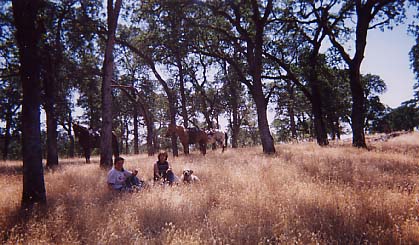
Picnic Lunch at Spenceville, in August |
Before visiting, check with the Dept. of Fish and Game, 916-538-2236. A
wonderful map, with all kinds of bird, wildlife and plant information, is
available from Grizzley Hill Productions, PO Box 2317, Nevada City 95959,
530-265-9495. You can also look at this map on your computer: http://www.gv.net/~rsthomas/
is the website for Friends of Spenceville. It’s best to take a look at a map
before you go, because this is a big piece of property!
From the staging area near the old copper mine (fenced, but be
careful!),cross the stream--still bubbling merrily along, 1’deep, 15’ wide,
in August--and turn left toward Waldo Bridge, or right up the hilly slope
where horses are allowed, or take the small trail back over the stream to
follow Old Spenceville Road trail, which will eventually come to Fairy Falls
in a few miles. Names of trails are not marked, but appropriate use signs
tell you which trails are open to equestrians.
Horses can drink from the stream at various points, but there are no
facilities for people, no tie rails, picnic benches or bathrooms.
DIRECTIONS:: Spenceville is easier to find now
that there are street signs here and there, but watch your odometer. >From
Loomis, take Sierra College Blvd. to Hwy 193. Turn left, then >turn right
onto East St (east of Hwy 65, opposite the huge pale green tank in
Lincoln operational yard), then turn right on 12th St. Next turn left on
McCartney (it’s called Harrison on the right). Continue 45 minutes on
McCartney to the metal bridge over the dam; go right at the Y onto
Blackford/Camp Far West Road. Pass the Camp Far West entrance, proceeding on
the dirt road. It is now well-graded, but dusty in summer. Start watching
the odometer here. At 3 mi., go left at the “T.” (This is about 1 hour so
far.) Now you’re on Long Ravine Road. At 5.5 mi., turn right onto
Spenceville Road--you’ll see an old “kiosk” on the far side of the road. At
7 mi., after you cross a little bridge, you will see a big open field on the
left, with a gate. Pull right in. The riding trails begin on the far side of
the parking field, through the stream. Trails are also available across the
dirt road, including big climbs and beautiful views, but these are more
subject to Fish and Game closures during nesting seasons, so leave plenty of
time to get back to the trailer before dark!
There are other accesses to
Spenceville, for instance coming down from Hwy 20 halfway between Marysville
and Grass Valley, but for riders leaving from the Loomis area, these
directions are probably more appropriate.
The Spenceville Area offers miles
of gentle trails for hiking and horseback riding. It is an 11,000 acre
nature preserve in which hunting is seasonally permitted.
|