| |||||||||||||||||||||||||||||||||||||||||||||
| Offshore
Coastal and Marine
Forecast: Monterey: http://www.wrh.noaa.gov/mtr/getcwfzone.php?sid=MTR&zone=PZ560 http://www.ndbc.noaa.gov/data/Forecasts/FZUS56.KMTR.html Short
and Long Term Monterey County Surface Forecasts: Tides: Monterey Harbor Whaler's Cove, Pt. Lobos Currents: Pt. Pinos Water Quality: Monterey County Beaches Water Quality |
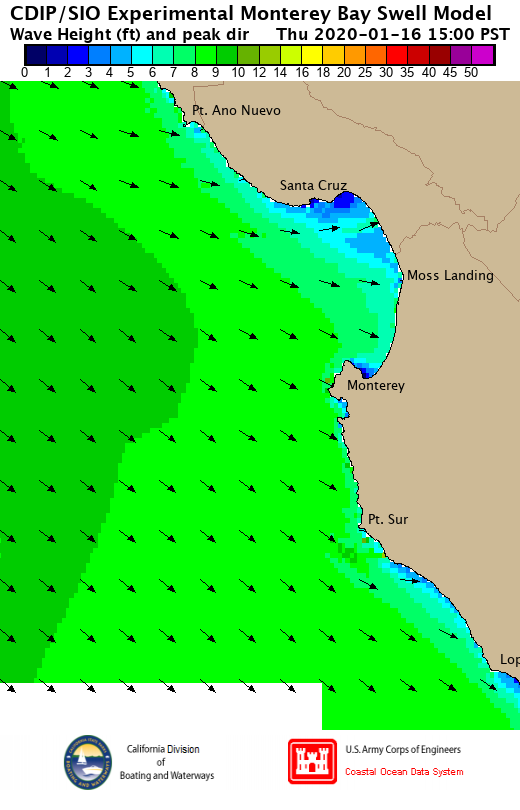 Scripps Monterey Swell Model |
||||||||||||||||||||||||||||||||||||||||||||
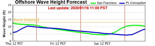 EXPERIMENTAL CDIP Offshore Wave Height Forecast |
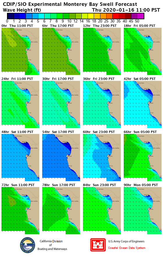 EXPERIMENTAL Four-Day Monterey Swell Model |
||||||||||||||||||||||||||||||||||||||||||||
 Fri 17 Jan 2020 04:00 PST |
 Fri 17 Jan 2020 10:00 PST |
 Fri 17 Jan 2020 16:00 PST |
 Fri 17 Jan 2020 22:00 PST |
||||||||||||||||||||||||||||||||||||||||||
 Sat 18 Jan 2020 04:00 PST |
 Sat 18 Jan 2020 10:00 PST |
 Sat 18 Jan 2020 16:00 PST |
 Sat 18 Jan 2020 22:00 PST |
||||||||||||||||||||||||||||||||||||||||||
 Sun 19 Jan 2020 04:00 PST |
 Sun 19 Jan 2020 10:00 PST |
 Sun 19 Jan 2020 16:00 PST |
 Sun 19 Jan 2020 22:00 PST |
||||||||||||||||||||||||||||||||||||||||||
 Mon 20 Jan 2020 04:00 PST |
 Mon 20 Jan 2020 10:00 PST |
 Mon 20 Jan 2020 16:00 PST |
 Mon 20 Jan 2020 22:00 PST |
||||||||||||||||||||||||||||||||||||||||||
 Tue 21 Jan 2020 04:00 PST |
 Tue 21 Jan 2020 10:00 PST |
 Tue 21 Jan 2020 16:00 PST |
 Tue 21 Jan 2020 22:00 PST |
||||||||||||||||||||||||||||||||||||||||||
 Wed 22 Jan 2020 04:00 PST |
 Wed 22 Jan 2020 10:00 PST |
 Wed 22 Jan 2020 16:00 PST |
 Wed 22 Jan 2020 22:00 PST |
||||||||||||||||||||||||||||||||||||||||||
 Thu 23 Jan 2020 04:00 PST |
 Thu 23 Jan 2020 10:00 PST |
 Thu 23 Jan 2020 16:00 PST |
 Thu 23 Jan 2020 22:00 PST |
||||||||||||||||||||||||||||||||||||||||||
 Fri 24 Jan 2020 04:00 PST |
 Fri 24 Jan 2020 10:00 PST |
 Fri 24 Jan 2020 16:00 PST |
|
||||||||||||||||||||||||||||||||||||||||||
|
Webcams |
|||||||||||||||||||||||||||||||||||||||||||||
| Top Down
| |||||||||||||||||||||||||||||||||||||||||||||
|
Fri 17 Jan 2020 04:00 PST | |||||||||||||||||||||||||||||||||||||||||||||
|
Fri 17 Jan 2020 10:00 PST | |||||||||||||||||||||||||||||||||||||||||||||
|
Fri 17 Jan 2020 16:00 PST | |||||||||||||||||||||||||||||||||||||||||||||
|
Fri 17 Jan 2020 22:00 PST | |||||||||||||||||||||||||||||||||||||||||||||
|
Sat 18 Jan 2020 04:00 PST | |||||||||||||||||||||||||||||||||||||||||||||
|
Sat 18 Jan 2020 10:00 PST | |||||||||||||||||||||||||||||||||||||||||||||
|
Sat 18 Jan 2020 16:00 PST | |||||||||||||||||||||||||||||||||||||||||||||
|
Sat 18 Jan 2020 22:00 PST | |||||||||||||||||||||||||||||||||||||||||||||
|
Sun 19 Jan 2020 04:00 PST | |||||||||||||||||||||||||||||||||||||||||||||
|
Sun 19 Jan 2020 10:00 PST | |||||||||||||||||||||||||||||||||||||||||||||
|
Sun 19 Jan 2020 16:00 PST | |||||||||||||||||||||||||||||||||||||||||||||
|
Sun 19 Jan 2020 22:00 PST | |||||||||||||||||||||||||||||||||||||||||||||
|
Mon 20 Jan 2020 04:00 PST | |||||||||||||||||||||||||||||||||||||||||||||
|
Mon 20 Jan 2020 10:00 PST | |||||||||||||||||||||||||||||||||||||||||||||
|
Mon 20 Jan 2020 16:00 PST | |||||||||||||||||||||||||||||||||||||||||||||
|
Mon 20 Jan 2020 22:00 PST | |||||||||||||||||||||||||||||||||||||||||||||
|
Tue 21 Jan 2020 04:00 PST | |||||||||||||||||||||||||||||||||||||||||||||
|
Tue 21 Jan 2020 10:00 PST | |||||||||||||||||||||||||||||||||||||||||||||
|
Tue 21 Jan 2020 16:00 PST | |||||||||||||||||||||||||||||||||||||||||||||
|
Tue 21 Jan 2020 22:00 PST | |||||||||||||||||||||||||||||||||||||||||||||
|
Wed 22 Jan 2020 04:00 PST | |||||||||||||||||||||||||||||||||||||||||||||
|
Wed 22 Jan 2020 10:00 PST | |||||||||||||||||||||||||||||||||||||||||||||
|
Wed 22 Jan 2020 16:00 PST | |||||||||||||||||||||||||||||||||||||||||||||
|
Wed 22 Jan 2020 22:00 PST | |||||||||||||||||||||||||||||||||||||||||||||
|
Thu 23 Jan 2020 04:00 PST | |||||||||||||||||||||||||||||||||||||||||||||
|
Thu 23 Jan 2020 10:00 PST | |||||||||||||||||||||||||||||||||||||||||||||
|
Thu 23 Jan 2020 16:00 PST | |||||||||||||||||||||||||||||||||||||||||||||
|
Thu 23 Jan 2020 22:00 PST | |||||||||||||||||||||||||||||||||||||||||||||
|
Fri 24 Jan 2020 04:00 PST | |||||||||||||||||||||||||||||||||||||||||||||
|
Fri 24 Jan 2020 10:00 PST | |||||||||||||||||||||||||||||||||||||||||||||
|
Fri 24 Jan 2020 16:00 PST | |||||||||||||||||||||||||||||||||||||||||||||
|
http://www.garlic.com/~triblet/swell/wamglance.html |
|||||||||||||||||||||||||||||||||||||||||||||


