 GPS
For the Monterey Diver
GPS
For the Monterey Diver
© Copyright, Chuck Tribolet, 1998, 2008
It's not my intention to give a basic course in GPS, or teach you how to use your GPS unit. The single most important source of information about your GPS unit is the MANUAL. Read it. RTFM. RTFM. RTFM.
The
GPS satellite navigation system can be very useful
to the Monterey
boat diver. First and foremost, it can get you home in the
fog.
It can also help you find dive sites, in the fog, at night, and even on
a clear day.
Dive Sites
Let's cut to the chase, and then come back to the techno-geek GPS stuff.Here are some of my favorite dive sites. And BTW, there are no secret dive sites in Monterey. There are a couple I don't tell people about, but they are both on Ed Cooper's map. There are others that the commercial boats showed me that I don't publish but (I do tell people about them) because I feel they "belong" to Phil, Ed, Dave, Tim, Xcott, Jim, and all the rest, and if you want to know where they are, pay to go diving with them. And there are some others that I don't publish fof
Safety is your responsibility and
only your
responsibility. The
easiest of these sites is advanced (or worse) on the worst of
days.
Some are advanced sites on the best of days. There are days to dive and
days to go have a nice lunch in Monterey. Make this choice
wisely
and conservatively, it's your life. I've only told you where
they
are. Whether you dive them or not is up to you and only up to
you.
Dive sites are rated by the
skill required to dive them
on a good day:
 -
Beginner.
-
Beginner.
 - Intermediate.
 -
Advanced. Note: An AOW card doesn't mean you are an advanced
diver. It means you have some of the skills and a little of
the
experience to be an intermediate diver, but may very well not even be
intermediate yet.
-
Advanced. Note: An AOW card doesn't mean you are an advanced
diver. It means you have some of the skills and a little of
the
experience to be an intermediate diver, but may very well not even be
intermediate yet.
 - Very Advanced.
All positions are WAAS/DGPS accuracy and datum
NAD83/WGS84. If you
don't understand what that means, see the section on Datums.
The positions are in degrees and minutes. I chose this format
because it can be copied and pasted into Garmin MapSource and other GPS
support software. N36 29.276 W121 57.373
means 36
degrees 29.276 minutes North latitude, 121 degrees 57.373 minutes West
longitude.
I've put some Pt. Lobos dive sites at http://www.garlic.com/~triblet/swell/gpslobos.html.
The sites have a link that looks like this: .
It's a Garmin MapSource .GDB file. If you have Garmin
MapSource
V6 and up, when you click the link MapSource will be opened and you can
download a waypoint for the site to your GPS. Note that
earlier
versions of MapSource supported a different format called
.MPS.
You can download a free upgrade to MapSource V6 from Garmin's website.
.
It's a Garmin MapSource .GDB file. If you have Garmin
MapSource
V6 and up, when you click the link MapSource will be opened and you can
download a waypoint for the site to your GPS. Note that
earlier
versions of MapSource supported a different format called
.MPS.
You can download a free upgrade to MapSource V6 from Garmin's website.
The site may instead have a link that looks like: ![]() It's a .GPX (GPS eXchange) file, which can be used with
Garmin
MapSource and many other programs. I'm in the
process of
converting the files to GPX, which is manufacturer agnostic and should
work with many brands of GPS receivers.
It's a .GPX (GPS eXchange) file, which can be used with
Garmin
MapSource and many other programs. I'm in the
process of
converting the files to GPX, which is manufacturer agnostic and should
work with many brands of GPS receivers.
The sites also have a link that looks like this:  It's a link to
a site that will draw you a map of where the dive site is.
It's a link to
a site that will draw you a map of where the dive site is.
Alan's Arch.
(AKA Arc de Triomphe) N36 29.276 W121 57.373
This is a rather amazing arch about 30' high bridging a sand-bottomed canyon off Yankee Pt. The bottom is at 110', the top of the opening at 80', the top of the arch at 70', and I've never been there without a ripping current. It's for very advanced divers only due to depth, current, and offshore location. Check out amazing color on the walls extending south from the arch. The site is named after Alan Cull, former captain the the former (here, it's now in SoCal) dive boat Pacific Star.
Lineups:
On Yankee Pt., line up the green spire on the
right hand end
of the three window house with the left hand chimney on the house
behind
it with two pink chimneys. And the Castle House on the 17
mile drive
is supposed to line up with some set of rocks at Pt. Lobos, but I've
never
been able to see that far.
The
Anchor Farm. See Kawika's Anchor Farm.
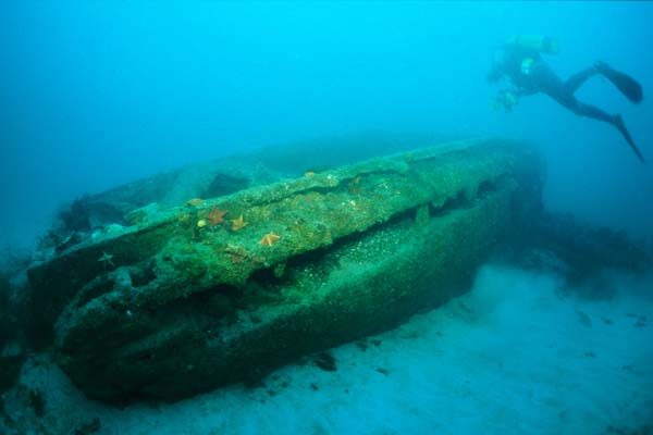
The
Amtrack (Del Monte Beach). N36 36.182 W121
53.136 This is a WW-II vintage amphibious tracked vehicle in about 25' off Del Monte Beach. Presumably it set sail from Ft. Ord intending on invading Monterey. It's usually dived in conjunction with the Sailboat. It's easiest to do the Amtrack first, then swim NE to the sailboat (about 110 feet on bearing 40° magnetic) Why the Amtrack first? Because the Sailboat is a bigger target and therefore easier navigation on the bottom.
The Amtrack itself is pretty
rusted, but you can still
see
pieces of
the the tracks laying next to it. It's NOT a half-track which
has
tracks and front tires, but rather an Amtrack, which is all track and
somewhat
amphibious (well, this one wasn't). Alternative spellings are
amtrak,
amphtrack , amptrack and combinations thereof. It's properly
called in Marine-speak an "LVT" (Landing Vehicle Tracked).
You
can find out more about Amtracks at http://www.wwiivehicles.com/usa/amphibious/lvt.html,
and http://www.globalsecurity.org/military/systems/ground/lvt.htm
There's usually kelp on the Amtrack, even in winter. Being shallow and sheltered, it's a different ecosystem.
Lineups:
The second story window on the first two-story
building on
Wharf 2 with the statue on the hill way behind it. The statue
is
getting kind of hard to see because of bushes, but if you know where it
is you can see it. I don't have another lineup -- the one I
used
to use was a sign behind Del Monte Beach that has disappeared.
There are two more, the Mating
Amtracks, off Lover's Point.
Aumentos Reef (aka George's
to the old guys). N36 38.315 W121 55.334
The best place to anchor is in the sand just NW of the main rock. Approach the main rock from the SE slowly. Go over the top, watch the depth finder, and as soon as it drops off to 55', drop the hook. (If it's a NW wind (usual case), go another boat length or two before dropping to avoid dragging the line on the rock.) Go down the line to the anchor, then swim SE. The rock is the size of a big two story house. The bottom's at 60', the top's at about 30'.
According to Ed Cooper: "George Gregor was an avid instructor and captain from Marin who re-discovered the rock in the mid 1970's. He took many divers there and dove it regularly."
Aumentos is reputed to be Spanish or Portuguese for "a rising up". Aumentos Reef should not be confused with Aumentos Rock which shows on the NOAA charts and is over by Eric's Pinnacle (but closer to shore and closer to Pt. Piños) and tops at 1'.
There's kelp on Aumentos, except in winter and early spring.
Lineups: Line up on the left side of Esplanade Street (big Cypress tree at the foot, small park farther up).
California
Diving News Site Review
Another
California Diving News Site Review
Note
that the GPS coordinates in both CDN reviews are
wrong for most everybody because they are in the old NAD27 datum.
The Barge
(dead center). N36 36.638 W121 53.409 The bottom is at 63'. This is an intermediate dive due to the depth and square profile. And make darn sure you can find the anchor at the end of the dive. The Barge is close to the line from the end of the breakwater to the mile buoy and there's a fair amount of boat traffic, so you want to follow the anchor line back to the surface and come up next to your boat. If you MUST surface away from the boat, swim SSW toward the breakwater on your safety stops. You do NOT want to surface offshore from your boat as that's where the boat traffic will generally be.
I'm back to using GPS for the
Barge. It had
the easiest
lineups in Monterey Bay: Line up the radio tower with the short red and
white smoke stack and line up the telephone pole at the end of the
concrete
part of the breakwater with the middle of the right-hand wing of the
Doubletree
Hotel. That would put you dead center in the middle of the
wreck.
Drift about 20' downwind before dropping the hook so you didn't damage
the wreck. Unfortunately, the smoke stack
disappeared. By eyeball,
I'm now using the triangular daymark at the end of the breakwater with
Monterey Bay Kayaks (the
second (and last) building on Del Monte Beach, with
a tin roof),
along with the telephone pole and the right-hand wing of the
Doubletree. Note: you have to be standing up to see
Monterey Bay Kayaks. You can't see it from water level, but
there's a house on the hill that you can identify if you swim a little
further east until MBK appears from behind the breakwall, then swim
back to the the drop point.
And a third
bonus lineup is: The gate onto the
Coast
Guard Pier has a chain link section that overhangs on each side to keep
people from just stepping around it. Line up the right-hand
side
of the chainlink with the nearest corner of the launch ramp
bathrooms. This one is particularly handy if you are surface
swimming from the beach because you can follow it all the way out.
The story is that the Barge is an old wooden sailing ship whose masts were removed and was being used as a cargo barge when it sank. There are charred portions, so it would seem to have burned before it sank. Interestingly, I can't find any reference to it in any of my Monterey County shipwreck resources. There's also a story that it's the ship that rescued Napoleon from Elba, but THAT ship washed up on Del Monte Beach and is still buried in the sand there.
I measured The Barge at 94' long, 9' 6" across. The size might help identify it.
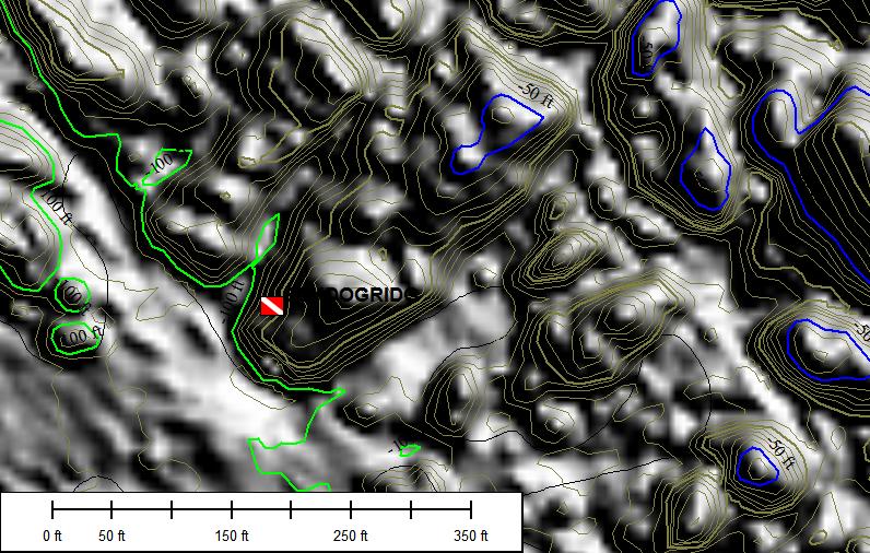
Black Dog Ridge.
N36 34.381 W121 58.840 
This site in the north end of Carmel Bay has beautiful
walls, but isn't dived much because it's very exposed. I've
never seen any other boat there, so it's named after my 17' Boston
Whaler, Black Dog.
The ridge runs more or less northeast to southwest.
The bottom is around 105'., the top at 60.
The best part of the dive is the sides of the
walls from 75' down to about 90'. There's a good anchorage just SW of the end of the ridge at N36 34.371 W121 58.842, but
please anchor clear of the ridge -- there's a lot of nice hydrocoral
right there. There's another good achorage off the east side of the ridge in sand at N36 34.381 W121 58.807.
Eric's Pinnacle, aka Eric's
Pinnacle Damit, aka EPD. N36 38.044
W121 55.101
The best place to anchor is in the sand north and northeast of the main pinnacle. Approach the main rock from the SW. . Go over the top, watch the depth finder, and as soon as it drops off to 55', drop the hook. Go down the line to the anchor, then swim SW. The top's at 19', the bottom's at 55'.
The naming of Eric's Pinnacle is a good story. Seems Phil Sammet and Eric Minard (Dave's brother) were out looking for sand to hunt some halibut. Phil was driving and Eric was watching the depth finder when they went over the pinnacle, which as a rather amazing (Matterhorn-like) profile. Eric: "Wow, look at that!" Phil: "You found it, what are you going to name it." Eric: "Eric's Pinnacle, damit!" Hence the alternative forms of the name.
There's kelp on Eric's, except in winter and early spring.
Lineups: I've heard lots of line ups and I can never find any of them. I can't even find my own at Eric's. ;-)
California Diving News site review
Inner Pinnacles.
N36 33.538 W121 58.032 Inner Pinnacles is a large reef (several acres), not just this one location. There's a spike to 15' in the NE corner somewhere, the general top around 30', the surrounding bottom is at 70' or deeper. Lots of kelp, lots of places to dive.
 Kawika's Anchor Farm.
There are four very large anchors (10 to 13 feet), two large concrete cubes (6 feet), and a lot of large chain (links the size of laundry baskets) in three groups at about 80 feet deep. I've numbered the anchors in the order in which I first saw them.
Anchor 01 and one block are under a big pile of chain at
N36 36.841 W121 52.925.
Anchors 02 and 03, another block, and a bunch of chain are at N36 36.874 W121 52.938. These are the most visually interesting because they are covered with red bryozoans. Please be careful of the bryozoans -- they have the structural integrity of a potato chip (and will stain your suit permanently).
Anchor 04 is at N36 36.875 W121 53.008 and there's a couple of hundred feet of chain running generally east from there.
Anchors 02, 03, and 04 are well-traveled -- this is the third location they have been in the two years. I wonder how many times they have been dragged before?
These anchors were first made known to the local dive community by Kawika Chetron in February, 2004, when they were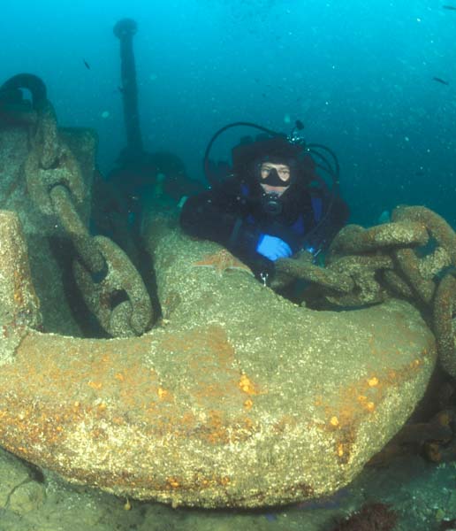 located at N36 36.822
W121 52.936. During June, 2004, the cruise ship Pride of Aloha
snagged anchors 02, 03, and 04 while pulling its own hook, and
dropped them at N36 36.856 W121 53.068,
682 feet away. John Yasaki did some detective work with the
harbormaster's office, and found that the cruise ship had recorded the
position where they thought they had put them down. John went
diving, and found them on the first dive.
located at N36 36.822
W121 52.936. During June, 2004, the cruise ship Pride of Aloha
snagged anchors 02, 03, and 04 while pulling its own hook, and
dropped them at N36 36.856 W121 53.068,
682 feet away. John Yasaki did some detective work with the
harbormaster's office, and found that the cruise ship had recorded the
position where they thought they had put them down. John went
diving, and found them on the first dive.The anchors got moved again on Oct. 28, 2005, by the cruise ship Norwegian Star, and went missing for a year. We had a position from the harbormaster, and many divers ran many search patterns looking for them to no avail. There were multiple reports of one anchor a concrete block and a pile of chain at about the location of anchor 01. Finally, in September, 2006, it all came together. First a diver named James reported that there was a second anchor in a pile of chain in the general vicinity of anchor 01. Then Marcos Perreau Guimaraes reported finding another anchor, with a bunch of chain, and it looked like the chain had been cut. I went and checked them out. James' anchor was really two anchors (02 and 03) and a concrete block, and Marcos anchor was 04. The cruise ship had cut the chain!
I measured the anchor Kawika is leaning on in the picture at 13' long, 8' 4" wide.
So how did these anchors come to be there? Monterey used to be an oil shipping port. Capt. William Matson (remember the Matson line, how you got to Hawaii before the Boeing 707?) built an oil pipeline from Coalinga to Monterey in 1904 to provide oil to the Hawaiian sugar mills. It terminated at several large oil tanks about where the Coast Guard Station is now. These burned in 1924, and the tank were relocated to Seaside, probably between the Del Monte offramp and the ocean.. The shale beds off Del Monte Beach are sometimes called Tanker Reef. http://www.tmx.com/pipeline/ has more information on the pipeline.
The Mating Amtracks
of Lover's Point. N36 37.787 W121 54.621 
 There's
one kinda beat up Amtrack
at
Del Monte Beach that has been a dive site for many years.
There
are two more, in better condition, one resting partially on the other
(mating? ;-), in the sand at about 80' off Lover's Point.
They
were originally found by Holger Fuerst. Why two in
one
place? One theory is a collision. Another is that
they
were moored together (there's a large concrete mooring block nearby),
one sprang a leak and dragged the other down with it.
There's
one kinda beat up Amtrack
at
Del Monte Beach that has been a dive site for many years.
There
are two more, in better condition, one resting partially on the other
(mating? ;-), in the sand at about 80' off Lover's Point.
They
were originally found by Holger Fuerst. Why two in
one
place? One theory is a collision. Another is that
they
were moored together (there's a large concrete mooring block nearby),
one sprang a leak and dragged the other down with it.
Interestingly, they appear to be different
models. The
top one is 24' 6" long, the bottom on is 22' 6". The top one
is
8' 3" wide (across the hull), and a bit wider across the treads.
I've seen as many as two wolf eels and a monkeyface eel on this site.
The Metridium Fields.
N36 36.744 W121 53.569
The Metridium Fields is a large general area covering several acres. The bottom is sand with rock outcroppings here and there with, duh, lots of the big white metridium anemones. It's also a good place to find Kellet's Whelks laying eggs in the late spring. The depth varies from 55' to 80'.
Never any kelp.
Lineups: the left side of Reeside Street (runs between the breakwater park and Monterey Bay Dive Center) in about 65'.
The
Sailboat. N36 36.193 W121 53.117
This is a 50' or so sailboat in about 25' off Del Monte Beach. It's usually dived in conjunction with the Amtrack.
There's usually kelp on the Sailboat, even in winter. Because it's shallow and sheltered, it has a fairly unique ecosystem.
The story as I got it (this is not guaranteed
reliable)
is that it was called The
Rouge and was
owned by Al Huelga (who owned Aquarius Dive Shops for many years) and
perhaps
some other folks, and they were planning on sinking it in a bit deeper
water as a dive site and artificial reef. While they were
struggling
with the bureaucratic paperwork, which dragged on and on, it sank
itself
where it is now. It's made of concrete.
This is not a spire or a pinnacle by any stretch of the imagination, but it's a nice reef to take newbies to. If I remember rightly (it's been a while), the top's at about 25', the bottom's at about 40'
I suspect Dave Minard named it to poke a little good-natured fun at fellow Cypress Charters Captain and deepster Phil Sammet. Phil deserves to have something better named after him.
![]() Shale
Island. N36 36.531 W121 52.786
Shale
Island. N36 36.531 W121 52.786
![]()
![]()
This is another one Kawika Chetron found.
Most of the structure in the shale consists of low cliffs running SE to NW, with the face towards the breakwater but Shale Island is a an exception. It's a raised area with a six inch to five foot clilff face outwards, with nice color on the cliff face and on top of the island. The island runs generallyh east-west, and is about ?? feet long by 10' to 150' wide. Depth is about 50'.
The GPS numbers are on a small bay at the west end of the north side. At the east end of the north side, there's a large Navy anchor with a heavily encrusted chain running due south nearly to the south side of the island. That;'s a good place to anchor too.
Never any kelp. The low relief can be hard to find on the depth finder, so have faith and drop the hook based on the GPS numbers. The bathymetry below shows the general shape. The blue line is the 15 meter (49.2 feet) contour. The island gets just a bit deeper at the east end and extends a bit beyond the blue line, but it's a pretty good outline of the rest. The fine brown lines are 5' interval contours, mostly at 55'.
 .
.
The Steam Engine.
N36 36.815 W121 52.985 This is a small single cylinder steam engine (boat type,
not
railroad). It's in about 75' on the deep shale.
There are
two small cliffs running SE to NW about 40' apart. The cliff
closest to the breakwater is a foot or so high, the other one is about
four feet high. The steam engine is located about five feet
from
the higher cliff. The GPS numbers will put the anchor on the
lower cliff. Swim NE from there to the steam engine.
GPS Unit Flavors
GPS units come in a number of flavors at various costs. Some aren't available to you and me.Standard Positioning Service without Selective Availability (SPS)
This is normal plain vanilla GPS today.SPS uses a single frequency and an unencrypted signal. Stated accuracy is better than 45 feet 95% of the time, it's actually probably more like 30' 95% of the time.
Contrary
to popular belief, SPS is NOT the magic high
accuracy flavor
used by the military. That's PPS (see below).
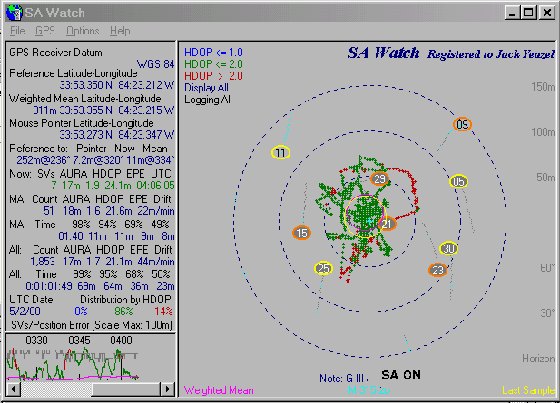
Standard Positioning Service with Selective Availability (SA) (gone now)
Until 0005 hours EDT, May 2, 2000, most (99.9999%) of the time, the least significant bits of the SPS signal were encrypted to degrade the accuracy so a hostile military couldn't use it against us good guys. At least that was the theory. This was called Selective Availability (SA) and is PROBABLY history, but it might come back again in a wartime situation. The military has decrypting receivers and the keys.Accuracy
was better than 100 meters 95% of the time, but
varied widely.
It frequently got near that 100 meter number. A three hundred
foot
radius covers 6.5 acres. When I had my boat parked in the
breakwater
parking lot and the GPS unit was in SA mode, the position on the
e-chart
wandered all over the parking lot, out into the harbor, up into the
Coast
Guard compound, and over into the park. This was good enough
to get
you home in the fog, and would get you close to a dive site, but
wouldn't
put
you ON the dive site. If the error varied slowly, you could
use SPS
to run a tight search pattern for a dive site, but it varied fairly
rapidly.
I've seen it go from one side of the 300 foot radius circle to the
other
in three or four minutes. It wandered a LOT.
I saw
an experiment where a GPS sitting on a shelf covered 41 miles in 24
hours
due to SA-induced variability
.
Wide Area Augmentation System (WAAS)
This is a DGPS variant that uses geosynchronous satellites (two for continental US) to transmit the corrections on the same sort of frequency as the GPS birds. This means almost no hardware required, just a little microcode in your GPS unit. My guess is that the incremental cost is between zero and $.25 per unit. WAAS is standard in almost all current GPS models -- check the specs to be sure. You may need to do a little setup to turn on WAAS.Raytheon (prime contractor for WAAS) claims 7' accuracy horizontally.
Differential GPS (DGPS)
Read the section on WAAS above before you buy a DGPS receiver.With DGPS, a ground-based beacon transmitter broadcasts corrections to the regular signal. These correct for SA, for atmospheric effects, and for slight inaccuracies in the orbit of the satellite.
Accuracy is 3-15 feet. That's good enough to drop the anchor in the same hole every time you go diving. It's GREAT for finding dive sites. When I'm parked in the parking lot, and the DGPS beacon receiver is turned on, the position wanders over an area no bigger than my boat.
In addition to your GPS unit, a DGPS beacon receiver is required. It receives the DGPS signal, and sends it over a cable to the GPS unit via what amounts to a serial port. A few very high-end GPS units have the DGPS beacon receiver built in, but in general a separate DGPS beacon receiver is required. DGPS beacon receivers cost (with antenna) between $180 and $600. Prices are dropping. Between Dec. 1997 and Feb. 1999, my Garmin GBR 21 dropped from $499 to $299. As of January 2001, the price is down to $180 for both the GBR 21 and the newer GBR 23 (which would be my choice today). Be sure to check that the one you buy is compatible with your make and model of GPS unit.
The Coast Guard runs a system of DGPS beacon transmitters. Also, reliable sources indicate that the Monterey Bay Aquarium has a beacon transmitter, but it's on a funny frequency that most beacon receivers can't handle. That's OK, the Coast Guard system is just fine.
On March 15, 1999, the USCG's DGPS beacon system reached "Full Operational Capability" mode and at that time became officially known as the Maritime Differential Global Positioning System (MDGPS). It covers the entire salt water coast (except for the very northern end of Maine), as well as the entire Mississippi River, parts of the Missouri and Ohio Rivers, and essentially all of the US parts of the Great Lakes. In addition, the Department of Transportation (which owns the USCG in peacetime) has announced that MDGPS will be expanded into a Nationwide Differential Global Positioning System (NDGPS). The first phase of this will be the conversion of several USAF Ground Wave Emergency Network (GWEN) sites to NDGPS beacons. One of the first of these was at Chico, CA. The importance of this is that as beacon transmitter coverage increases, the sales of DGPS beacon receivers will go up, and the prices will go down. If the market should decide that most GPS units should have DGPS builtin, the incremental cost could go as low as $25, however this is unlikely to happen due to the advent of WAAS (see below).
USCG beacon transmitters of interest to the Monterey diver are:
- Pigeon Pt. (about half way between Santa Cruz and Half Moon Bay). This is the primary DGPS beacon for the Monterey area. It transmits on 287 KHz at 100 bps.
- Point Arguello (down by Hearst Castle). It makes a good backup to Pigeon Pt. It transmits on 321 KHz at 100 bps.
- Point Blunt (Angel Island). This is a relatively low powered beacon primarily intended for use in San Francisco Bay, but it can sometimes be received in the Monterey area. I've also used it on bay area lakes such as Calero and Anderson. It transmits on 310 KHz at 200 bps.
- Cape Mendocino. Just what you need to come back next year and find that crack full of ALMOST legal abs. It transmits on 292 KHz at 100 bps.
- Chico. This features a 300' antenna and LOTS of power. Nominal range is 250 miles (compared to 180 miles for Pigeon Pt. and Pt. Arguello, and 60 miles for Angel Is.). It transmits on 318 KHz at 100 bps.). This is one of the first NDGPS sites.
- Lincoln. This is a "proposed future location" for an NDGPS site.
Precise Positioning System (PPS)
This is a two-frequency system used by the military. I don't know how accurate it is. If I knew, and I told you, they'd throw me in jail. Certainly better than SPS (45 feet), quite possibly better than DGPS. You can't get it, you won't be able to get it for the foreseeable future, so don't worry about it.News
flash: I found an unclassified Coast Guard document (Design
Process for the United States Coast Guard's Differential GPS Navigation
Service) that states that the accuracy of PPS is 21 meters
95% of the
time. Mmm, that's not as good as SPS. Something's
wrong here.
I've also found another document that indicates that PPS is the same as
SPS without SA. On the other hand, Tim Doreck pointed out
that if
PPS were good to, say 1 meter all of the time, it would still be
accurate
to say that it was good to 21 meters 95% of the time. And US
nuclear
subs have a speed of better than 20 knots (probably a lot
better).
Carrier Phase Differential GPS
This is a different flavor of DGPS that uses the phasing of the carrier waves. Accuracy is better than a centimeter over relatively limited distances (a few kilometers) from the beacon transmitter. It is expensive (five digits) and is used by surveyors instead of transits and tape measures. It would be overkill for diving, probably not waterproof, and more expensive than your boat, so don't worry about it.Let's Compare
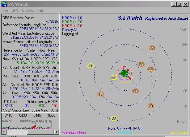
There are three plots below. Although taken at different times and places, this accuracy is typical. The colored circles with numbers in them represent satellite positions. Ignore them.- The top plot above shows the (lack of) accuracy of SA. This happens to be the last hour SA was on. Note that all the positions are within about 75m of the actual position.
- The middle plot shows accuracy of SPS (SA off, but no DGPS). Note that all positions are within about 12m of the actual position.
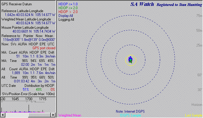
- The bottom plot shows DGPS with SA on (DGPS with SA off should be just at touch better). Note that the scale is larger, and that all positions are within about 2m of actual.
What to Look For in a GPS Unit
Form factor. What shape do you want your GPS unit to be? GPS units come in three basic shapes:- Small handheld. These are small, light, and very portable. The down side is a relatively small screen size, typically 64x100 pixels, but there are starting to be some with higher resolution screens. Their primary power source is AA alkaline batteries. An additional cord will allow them to run off your boat's 12V system.
- Luggable. These are about the size of a brick. I wouldn't take one backpacking but I regularly take one on other people's boats. The screen sizes are larger, typically 160x240. Their primary power source is AA alkaline batteries. An additional cord will allow them to run off your boat's 12V system.
- Console mount. These are non-portable. They run off the boat's battery (that's a problem if your boat doesn't HAVE a battery). If you want to take them in the house and program them while you have a beer in front of the fireplace, you need a 12V power supply (try Radio Shack ). But they have nice big screens, ranging from 64x102 to 640x480. Some of them will double as a depth finder, but bear in mind that takes up screen space.
Display size. The display size varies with price. The higher the price, the bigger the display. I find the low end units too small for boat navigation. Think about where your eyes will be relative to the GPS unit. Think about the other things you need to be doing at the same time (like watching for wakes and big waves). And if your GPS unit is also your depth finder, that takes up display space.
But don't confuse physical screen size with resolution. There can be a wide range of physical screen sizes with the same resolution. Just because it has a bigger screen size doesn't necessarily mean you are going to see more detail. Check the screen size in pixels to see how much detail it can show, and check the physical screen size to see how far away you can read it from.
Waypoints. All GPS units have the ability to remember and name positions. These are called waypoints. I call them DIVE SITES. You can also program in the position of key locations on your course home in the fog. You can typically enter the position of a waypoint by physically going there and pressing a button, keying in the latitude and longitude, or (if your GPS unit has one), positioning the cursor on the e-chart and pressing a button.
Man Overboard (MOB): Most GPSs have a way to very quickly enter a waypoint and start navigating to it. It's intended for use if someone falls overboard, but I also find it useful for quickly marking a pinnacle I just went over, then I go back and get exactly on the pinnacle at slow speed and create a permanent waypoint. I also find it useful if I think I might be dragging anchor -- the distance to the MOB point will start at zero and get bigger and bigger if you are dragging.
Routes. A route is a chain of waypoints. The GPS unit will typically tell you the bearing and distance to the next waypoint on the route, and display a screen that looks like you are driving down a highway from waypoint to waypoint. This is a good way to navigate in the fog.
Track. The GPS unit will remember where you have been. You can program the resolution (how often to save the position). I have my Garmin 162 programed to save a track point every five seconds -- this makes running search patterns much easier, and it will remember five or six hours worth of track.
Chart capability. Most luggables and midrange and up console-mount GPS units will take plug-in chart cartridges or can download charts from a CD on your PC. You see your position superimposed on a chart which makes learning to use the GPS MUCH easier. It also teaches you the names of all the points and canyons.
The cartridges are expensive ($250-400 for some, though prices are getting down into the $99 level for most now). Generally, they are only available from the GPS unit manufacturer. I expect to see those prices come down as soon as there is some competition. The level of detail on the chart is significantly less than that on the NOAA paper charts. I expect to see the level of detail go up over time. Charts are very helpful for helping you to learn to use your GPS unit. Charts capabilities come in several flavors:
- None. The inexpensive units may have a real simple built-in chart or no chart capabilities at all.
- Nautical. Most of the midrange and up units will take nautical charts.
- Street map. Some units will only take street maps. This isn't terribly useful to the boater.
Antenna. Where is the antenna? GPS signals won't go through much. Some won't even make it through my hand! Unless your GPS unit has a clear view of the sky where it is mounted, you will need an external antenna. Resist the urge to mount the antenna real high. The satellites are hundreds of miles up, so mounting the antenna a couple of feet closer on a pole won't help. The best place to mount an antenna is smack in the middle of a horizontal metal plate. That will minimize problems with multipath signals (ghosts) bouncing off the water.
DGPS ready. Essentially all modern GPSs are DGPS ready. You have to add a differential beacon receiver, which will run about $250-600. A few high-end GPS units have built-in DGPS beacon receivers, and end up being less expensive than the combination of a midrange GPS unit and a DGPS beacon receiver. I think we'll see DGPS beacon receiver prices come down below $200 (that's the increment on the built-in ones) over the next couple of years, and see DGPS beacon receivers built into some mid-range units. It's possible that the cost increment for a built-in DGPS beacon receiver may get down into the $50-100 range (but that will be without antenna -- add $40) IF DGPS gets popular.
WAAS. I think most new units are going to be WAAS ready. There's essentially no manufacturing cost, and competition has already erased any price difference.
Power supply. GPSs EAT batteries. If your boat has a 12V battery, get the right cord to power your GPS unit. Get a hardwired cord, not a cigarette lighter cord, and connect it properly. Use marine grade connectors, solder what can be, crimp what can't, and cover everything with hot melt lined heat shrink. Even so, carry a couple of spare sets of batteries in your dry box.
Cost. Here's the big variable. Prices vary all over the map. The last single channel GPS unit left on the market closed out at under $100 dollars. There are 12 channel units for $119. The mid-range receivers are about $400. The best high-end receivers are close to $2K. Generally, you get what you pay for. More money gets you a bigger display, e-charts, and a built-in DGPS beacon receiver. Prices will include an antenna, but, for hand-helds and luggables, will not include a mounting bracket or power cable.
More money buys more features, but not more accuracy, except when it adds WAAS or DGPS. The inexpensive units are just about as accurate as the non-DGPS expensive ones.
Prices for the same GPS unit can vary by as much as 25%, so shop around. West Marine's prices are pretty good. http://www.tvnav.com/ has even better prices. At West you can walk out with it today. In any event, pick up West's Master Catalog for $5. It has a good two-page overview of GPS, and they carry most all of the interesting units so you can comparison shop.
Weatherproof.
Most GPS
units are relatively weatherproof,
but check out things like the battery pack. My Garmin 175 was
well
sealed, but the removable battery pack had no gasketing at
all. Also
be careful with the little door over the chart cartridge.
They are
often sealed with a rather cheesy little O-ring.
GPS Is NOT Perfectly Reliable
I have seen a couple of cases where my GPS unit gave completely wonky positions. One time I was anchored off Del Monte Beach, and it decided I was several hundred miles to the southwest, and at a depth of 7000 feet. Another time I was anchored just south of Pt. Lobos and it decided I was in the mountains of Big Sur. In both cases, powering down and reinitializing the system cleared up the problem. Another time I was off the Aquarium and it thought I was about 10 miles northwest of there making about 120 knots! A power cycle did not clear up this problem.Given this, and the fact that electricity and salt water don't mix well, you need a back up. I carry NOAA charts of Monterey Bay and the Big Sur Coastline sealed in a huge ziplock bag, and a compass and stopwatch mounted on the console. Course, distance, and time are already plotted to get me home in the fog by dead reckoning if need be.
Datums
The datum is the reference point for position. It defines where the latitude and longitude lines are relative to the land. There are three horizontal datums of interest in the Monterey area:- NAD83 (North American Datum of
1983). This was generated from
early satellite data and is more accurate than NAD27. All
modern
paper charts use it, and it is the default for most GPSs.
- WGS84 (World Geodetic System
of
1984). This is essentially the same
as NAD83. It differs only by millimeters.
- NAD27CONUS (North American Datum of 1927, Continental US). We'll just call it NAD27. A few older nautical charts still use this. Many USGS topographic maps use it. More importantly, the older Garmin G-charts are NAD27. I find this amazing, given that the paper charts that the G-charts were drawn from have used NAD83 for some time. It's what I used early on because I had the G-charts. If I didn't have the G-charts, I'd have used NAD83. (Late news: In the fall of 1999 Garmin revamped their charts, and they are now WGS84.) NAD27 was laid out by traditional surveying techniques (transits and tapes and such) starting from Meade's Ranch, Kansas. Obviously, there is going to be a significant amount of error by the time a survey line is run all the way to California. I'm amazed that it's as accurate as it turned out to be: five thousandths of one percent, which is less than a steel tape would have changed due to a 1 degree change in temperature.
The good news is that most GPSs will take care of this for you. They maintain positions in their own internal format, and convert them to the appropriate datum as required. If you get a position in a different datum than you normally use, change your GPS unit over to the oddball datum, enter the position, then change the GPS unit back to your normal datum, and the position will get converted. NOTE: Make a backup before you do this, just in case your GPS unit is one of the few that won't handle it.
The Coast Guard website makes a big deal that DGPS is for use with NAD83. Don't worry about it -- the way DGPS works, the corrections are applied way before the software worries about datum, so the datum will not impact DGPS accuracy in any significant way. It will just give you positions relative to a slightly different grid on the earth's surface.
There's more than you ever wanted to know about datums at http://www.connect.net/jbanta/Welcome.html.
Making Backups
A GPS unit is a small computer. It's small enough that it could be lost or stolen. It could die. Or the little coin cell inside that maintains the memory could die. In any event, you don't want to lose all the information you have carefully stored in it.Just like with your desktop computer, you should make periodic backups of the waypoints and routes you have stored in it. The cheapest way is with pencil and paper. The easiest way (at lest for computer nerds like me) is by connecting your GPS unit to a computer and downloading into the computer. You will need a serial cable that matches your GPS unit, and appropriate software. In the past, I used a program called Waypoint, see http://www.tapr.org/~kh2z/Waypoint/. Now, since I need Garmin MapSource to load cartography, I use MapSource to make backups. You should also check your GPS unit maker's website for software.
Just about every time I hook the GPS up to the computer, I make a backup on general principles. MapSource saves data in .MPS files. I download waypoints, routes, and saved tracks from the GPS, then save them in a file named <GPS>_<year><month><day>.MPS. For example, if on March 6, 2001 I made a back up of my GPSMAP 162, it would be saved in a file named GPSMAP162_20010306.MPS.
My GPS System
I have a Garmin GPSMAP 162 (console mount) and run it with WAAS enabled. The GPSMAP 162 is mounted on top of the console of my Boston Whaler in the Garmin bracket. I use an external antenna mounted to the top of the console rail and draw power from the boat's electrical system.I used to have a Garmin GBR21 DGPS beacon receiver, but when WAAS came along, I switched to WAAS and donated the GBR21 to a worthy cause (a mapping project up at Henry Coe State Park).
Learning to Use Your GPS unit
The time to learn to use your GPS unit is NOT when you surface after a dive and discover that while you were on the bottom surface visibility has become worse than on your dive. Learn to navigate with it routinely when the weather is clear. Practice getting home using your waypoints. Then, when the fog does close in, you can concentrate on navigation, not education.The Fog Bound Route
Here's a route I call "Fog Bound". It's designed to get me home in the fog. It's also useful for navigating to the general vicinity of many dive sites. In general terms, it runs from the breakwater launch ramp out of the harbor, northwest to Point Piños, southwest to Cypress Point, southeast to Point Lobos and south almost to Point Sur. Use it at your own risk.All positions are NAD83/WGS84, but be sure to read the section above on Datums.
-
RAMP: The end of the breakwater launch ramp.
-
36°36.536'N 121°53.614'W
-
36°36.462'N 121°53.366'W
-
36°36.509'N 121°53.319'W
-
36°37.462'N 121°53.743'W
-
36°38.697'N 121°55.475'W
-
36°38.846'N 121°56.695'W
-
36°37.053'N 121°58.256'W
-
36°34.350'N 121°59.825'W
-
36°31.215'N 121°57.991'W
-
36°29.322'N 121°57.411'W
-
36°27.349'N 121°56.484'W
-
36°24.096'N 121°55.483'W
Links to Other GPS Pages
U. S. Coast Guard
USCG Navigation Center: http://www.navcen.uscg.gov/USCG Navigation Center GPS Info: http://www.navcen.uscg.gov/systems/default.htm
Private Pages
SA - The Movie: http://www.ualberta.ca/~norris/navigation/GPS/PlotSA.htmlDavid L. Wilson's GPS Accuracy Page: http://www.erols.com/dlwilson/gps.html
Joe Mehaffrey's GPS Page http://joe.mehaffey.com/
Manufacturers
Eagle: http://www.eaglegps.com/Garmin: http://www.garmin.com/
Lowrance: http://www.lowrance.com/
Magellan: http://www.magellangps.com/
Northstar: http://www.northstarcmc.com/
Raytheon: http://www.raymarine.com/recreational/products/index/navaids/index.html
Standard-Horizon: http://www.standardhorizon.com/
Trimble: http://www.trimble.com/
Retailers
REI: http://www.rei.com/West Marine: http://www.westmarine.com/
West Marine's words of wisdom on GPS: http://www.westmarine.com/webapp/wcs/stores/servlet/westadvisor/10001/-1/10001/selectingagpsreceiver.htm
TVNav.com: http://www.tvnav.com/
http://www.garlic.com/~triblet/swell/gps.html
Last updated: 04:52 PM, Thursday, February 17, 2011.
Webmaster: Chuck Tribolet, triblet@garlic.com