 Monterey
Bay Sea Conditions
Monterey
Bay Sea Conditions
Some Examples
Chuck Tribolet, triblet@garlic.com
© Copyright, Chuck Tribolet, 1997, 1998, 2001, 2004
since March 4, 2002
Chuck's Tongue in Cheek Guide to Swell Heights
8' - Typical for Monterey. May be diveable, but I'd rather sort slides.10' - Go only if you've already paid for the boat. And they MAY cancel.
12' - Stay out of the water.
14' - Stay off the beach. Not uncommon in winter.
16' - Stay off Highway One. Occurs a couple of times each winter.
And on the good end:
6' - Passable Diving.
4' - May be worth a vacation day to dive midweek. Not uncommon. Four foot days are why I check these resources every day.
2' - Quit your job. Go diving. (The lowest I've ever
seen is 3').
Don't forget that swell direction is important. Remember a few years ago when Santa Cruz was getting hammered by southerly swells from a hurricane off Tahiti, and the TV news had tape of a fishing boat getting capsized in the mouth of Santa Cruz harbor? Monterey Bay was flat — all that granite was protecting the bay. But watch out for "northwest". If it's a bit north of true northwest, Ano Nuevo protects Monterey Bay. And if it's a bit south of true northwest, Pt. Pinos protects the bay. But if it's truly northwest, there's no protection at all, and the Breakwater can look like Monastery.
Actually, this is really only a little bit tongue in
cheek. The
offshore Coastal and Marine forecast is the first thing I check.
If it's
a northwest swell, and 8' or less, I go diving. If it's a west
swell
and 10' or less, I go diving. If it's a southwest swell (VERY
rare), I
go diving. Simple, right? Note that your thresholds may
vary: I'm a photographer, and surge makes photography difficult, so
maybe I'm a tougher grader than some. And some folks can only
dive occasionally, and want to chery-pick the very best days.
But above all, these resources aren't perfect. They only advise when to take your gear to the beach. When you get there, look at the conditions, and decide whether to dive there that day. There are a fair number of days when the best action is not to dive in the ocean but rather into a pitcher of beer, pizza, and dive talk.
Some Examples
By popular demand, here are examples of some memorable days in Monterey, and how to interpret the information available. I've shown a very good day, and a very bad day. There's a whole range in between, and each person's skill level will determine where their "don't dive" line is. Over time you'll learn what's worth driving to Monterey for, and when to stay home. Most importantly: these resources can help you decide when to drive to Monterey, but the decision to dive shouldn't be made until you are on the beach, and have watched the waves for a while. There are many times and places to dive elsewhere or elsewhen.The Times, They Are a' Changin'
Since I captured these examples, some changes have taken place. The WAM model examples on this page are in Interactive Data Language (IDL) 4.0 format. IDL 5.0 is now used, and there are a number of changes:- The aesthetics of the images are greatly improved. They are quite pretty and might be considered art by some.
- The wave height scale is now continuous as opposed to having discrete colors for 3-6, 6-9, etc. feet. And it's in meters. Three feet is about one meter, OK? There are also no contour lines. I find this makes it harder to read the wave height. I'd really like to see continuous AND contour lines.
- The arrows are bigger. I think they are about the right size.
- Because of the continuous colors, the images don't compress as well, and are about 3x bigger (90K vs. 30K).
- A different progression of discrete colors is used for wave heights. Light blue is good diving. Darker blue is OK diving. They are still in feet for us Luddite Americans.
- Some of the colors, esp. 3-6 and 6-9 feet, are too close together.
- The arrows are bigger. I think they are about the right size.
I usually use the GrADS format.
Why Don't the Models Agree?
Well, first and foremost, forecasting is an extremely inexact science. It has only recently gotten so that the models are more accurate than "tomorrow will be just like today." If you ever wonder why all these supercomputers can't do a better job of forecasting, read a book on Chaos Theory. I recommend James Gleick, "Chaos", ISBN 0-14-00.9250-0.Measurement error. You try measuring swell heights sometime.
Lawsuit prevention. It seems to me that the forecasts tend to be pessimistic about the size of the forecasted swells because they are unlikely to be named as a party in a suit if the swells are smaller than predicted.
Different definitions. Some measurements specify that 15% of the swells will be bigger than the prediction, and 15% will be smaller. Others take the mean of the largest third of the swells. It only take one really big one you weren't expecting to scare the stuffing out of you.
Different point of measurement. Buoy 46042 is in one place.
"Pigeon Pt. to Pt. Piedras Blancas" is large area (which happens to contain
46042). The "three-day model" is done by taking the WAM forecast
for a single point, and applying the diffractions due to underwater topography
and shoreline reflections. That single point is farther out than
46042.
When Are the Various Models Updated?
The Coastal and Marine Forecast is updated four times daily (3:00 a.m., 9:00 a.m., 3:00 p.m., and 9:00 p.m.) and appearson the web shortly thereafter. Occasionally updates are made more often.
The WAM model is usually updated twice daily, usually around noon and midnight.
The Monterey Bay Swell model is updated hourly, and usually lags real time by two to four hours.
The Experimental Three-Day Forecast and the Offshore Wave Height Forecast
appear to be updated twice daily, but I haven't managed to puzzle out just
when.
A Note on Swell Intervals
The longer the interval, the deeper the swells reach. The shorter the interval, the nastier the ride in a small boat. I remember one day on the Pinnacles when we'd had a nice flat ride down and there were SW swells that were only about two feet high, but they had a real long intervals (18+ seconds), and I couldn't get under the surge. The only saving grace is that with the long interval, I could get a picture or two off during the calm between the surges. On the other hand, I remember another day with really short interval (six seconds) swells of 6-8 feet. I'd decided I wasn't going to try to get down to Carmel Bay before I even got to the red mile buoy. The ride was like a roller coaster. But sites like Eric's and George's (Aumentos) were quite diveable and had no surge.If you would like to learn more about all this, see Willard Bascom,
Waves
and Beaches, Anchor Books, 1980, ISBN 0-385-14844-5. Amazon.com
lists it as "hard to find", but it's worth a shot. Bascom did a lot
of the basic surveys of California beaches in the late 1940's using a DUKW,
which is a big amphibious truck used by the military. The book includes
a picture of Bascom surfing the DUKW at Carmel River State Beach on a day
when I sure wouldn't dive. He's standing up taking depth measurements
with a lead line. The book is worth the price just for that picture.
Conditions Today Don't Mean Anything Tomorrow
In fact, conditions this morning don't mean anything this afternoon.Conditions are highly variable. Just because it's nice today doesn't mean it will be nice tomorrow. It could just as easily be bad tomorrow. Conditions can go from flat glassy to very nasty in a couple of hours. One morning I ran my whaler down to Carmel Bay in about 30 minutes under quite nice conditions. We did a first dive a MonoLobo Wall. During the surface interval, things started to pick up a bit. I did a second dive while my girlfriend sacked out on the bow locker. She was awakened by a wave breaking over the bow. We had an hour and a half run home at a fast idle. It was the nastiest small boat conditions I've seen.
Stay alert to the short-term trends in conditions.
Conditions Here Don't Mean Anything There
Conditions at home don't necessary reflect what's happening in Monterey.First the microclimates are different.
Secondly, most of what's happening in the ocean is an effect of the
above-water conditions thousands of miles away and several days ago.
A REALLY Good Day for Monterey Divers
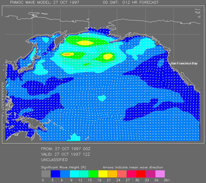
First, let's look at a truly wonderful day. Monday, October 27, 1997. I dove North Monastery Beach that day. The BIG sets were about 12 inches high. There was 40' vis and no surge in the shallows, and some friends diving the wall reported 50' vis deep. It was well worth taking a half day of vacation.Since the WAM model provides the earliest warning of impending good conditions, let's look at it first. You are looking at a map (slightly distorted in the northern regions because of the projection) of the Pacific Ocean. (Note: I added the place names with PhotoShop to help the navigationally impaired. They don't appear in the real WAM model.) Dark Blue is good diving. Light Blue is OK diving. Note the little arrows that show the direction of the swell. Now find San Francisco Bay (it shows, just barely). Note that the swells are coming from the WSW or SW, which means that Pt. Lobos will shelter Monastery (and the Monterey Peninsula will shelter the bay, but why dive the bay when Monastery is a walk-in, walk-out dive).
The "From:" time is when the model was run. The "Valid:" time is when the model thinks the ocean will look like the picture. The times are GMT, aka Zulu, which is 8 hours (7 hours during daylight savings time) ahead of Pacific time. 12Z is 4 a.m. Pacific Time the same day. 00Z is 4 p.m. Pacific Time the PREVIOUS day. That means this picture was generated at 4 p.m. 26 Oct. 1997 Pacific Time, and represents the ocean at 4 a.m. 27 Oct. 1997 Pacific Time.
I was watching the WAM model and knew a couple of days ahead that I'd
probably want to go diving on
Monday. Here's what it looked like:
Now it's Monday morning. To dive or not to dive. Let's look
at the Coastal and Marine Forecast.
Pigeon Point is half way between Half Moon Bay and Santa Cruz.
Point Piedras Blancas is by Hearst Castle.
NATIONAL WEATHER SERVICE [Image] |
Now lets look at some of the less obvious things here:
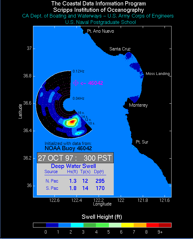
- The "bulls eye" (well, two thirds of one) shows where the wave energy is coming from and the period of the waves. The color coding is NOT the same as used on the map part. Note that most of the energy is coming from the SSE! Wow, protection from Pt. Sur. This is getting better and better. The distance from the center of the bulls eye is determined by the wave period (time between waves). The outer edge is about eight seconds, the inner edge is about 24 seconds. I don't find wave period to be very useful.
- In the box with the numbers, "Hs" is the "significant height', which is the average height of the highest third of the waves and is in feet. "Tp" is "typical period", the average period of the waves. "Dp" is the direction the waves are coming from. I find the bulls eye chart much more useful than this text box.
- The little magenta cross is the location of the buoy. It's about 20 miles out.
A REALLY Bad Day for Monterey Divers
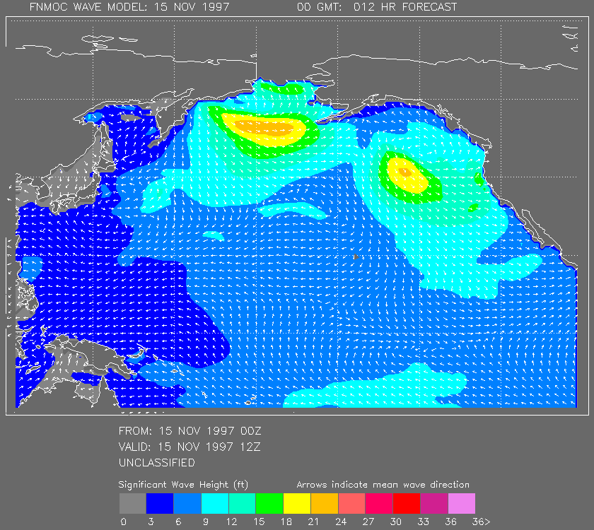
Saturday, November 15, 1997. The Nikon Underwater Photography Tournament is today. The swell reports on the web are really ugly. I'm staying home and writing this article instead of taking my Nikonos to Monterey and trying to win fame, fortune, and some cool prizes.Again, we'll look at the WAM model first again. All that turquoise (9' to 12' swells) is not good news, but the pale green (12' to 15') and bright green (15' to 18') are even worse. This does not look good. The only glimmer of hope is that the swells are from the West, and MAYBE there's a little shelter in the bay. Copper Roof is probably getting really hammered.
There's a little skinny band of blue just a couple of pixels wide right along the coast. If you have young eyes or have a real good monitor, and can see it, ignore it.
Here's the Coastal and Marine Forecast. It's just as ugly.
ZCZC SFOCWFSFO |
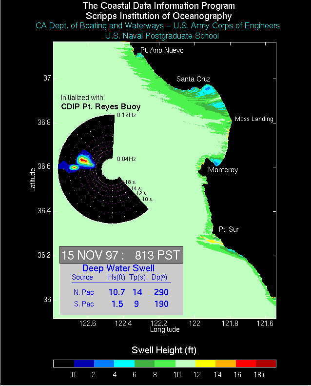
Note that the scale has changed to accommodate the big swells.
Red now means 16-18' not 8'-9'. The good news is that this looks
better than it did yesterday when it was ALL 16 feet or more.
Right NOW!
Want to see what it looks like right now? Go to: http://www.garlic.com/~triblet/swell/wamglance.html.More Information
For information about Internet resources for the Bay Area diver, see http://www.garlic.com/~triblet/swell/. For information about using GPS for diving in Monterey, see http://www.garlic.com/~triblet/swell/gps.html. For information about the Northern California Underwater Photographic Society (NCUPS), see http://www.ncups.org.http://www.garlic.com/~triblet/swell/Inet1XMP.html
Last updated: 06:23 PM, Tuesday, February 28, 2006.
Webmaster: Chuck Tribolet, triblet@garlic.com